
RTLS, RFID or Vision: Choosing Container Positioning Tech
- Posted On: October 15, 2026
- Post Comments: 0
Knowing where every container physically sits is the hardest problem in the yard, and there are three families of answer. Tags, satellite positioning fitted to handling equipment, and camera derived location all feed a container terminal management system with position data, and they differ far more in cost and failure behaviour than in headline accuracy. This article compares them on the criteria that actually decide the outcome, and sits alongside the wider yard series.
Key Takeaways
- Accuracy is rarely the differentiator. What separates these technologies is installed cost, behaviour on unreported moves and how much ongoing maintenance each demands.
- Tag based systems track continuously and require a reader and tag estate across the yard, which is a capital project with a permanent maintenance obligation.
- Satellite positioning on equipment is cheaper and inherits every equipment reporting gap, because it infers container position from machine position rather than observing the box.
- Camera derived location observes rather than infers, and where cameras already exist for gate or crane work the incremental cost is software rather than hardware.
The Question These Technologies Are Answering
Every positioning technology exists to answer one question: where is this container, right now, in physical reality rather than in the record. The reason the question is hard is that containers are moved by machines and people who are working at pace and are not primarily employed to record data.
That framing helps because it separates the technologies by how they answer. Tags report a position from something attached to the object. Equipment positioning infers a position from where the machine was. Cameras observe the object where it sits.
Those three approaches fail in different ways, which matters more than their accuracy specifications. A system with excellent accuracy that stops reporting when a box moves outside its scheme is worse in practice than a less precise system that keeps seeing everything.
The second useful framing is cost shape. Some approaches front load capital into an estate that then needs maintaining. Others convert the problem into software running on infrastructure you already have, which changes both the approval process and the payback profile.
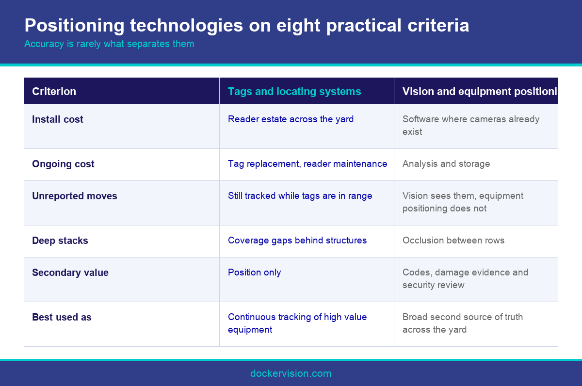
A third consideration is what else the technology gives you. A camera installed for positioning can also read codes, capture damage evidence and support security review. A tag reports position and nothing else, which is a narrower return on the same capital.
Keep those three lenses in mind through the comparison. Terminals that evaluate on accuracy alone routinely choose the technology with the best specification sheet and the worst fit for how their yard actually operates.
It also helps to be clear about what the container terminal management system does with the answer. Position data that is never routed into a work queue changes nothing, so the technology choice should be made alongside the integration design rather than before it. A precise position nobody acts on is an expensive way to be well informed.
Tags and Real Time Locating Systems
A real time locating system attaches an active tag to handling equipment, or in some designs to containers, and triangulates position from fixed readers installed around the yard. Position updates are continuous and accuracy is typically good enough to identify a specific slot.
The operational appeal is genuine. Continuous tracking of every straddle carrier and reach stacker gives a live picture of equipment deployment as well as cargo position, and it supports safety and productivity analysis that other approaches do not.
The cost is the estate. Readers have to be mounted, powered and networked across the operating area, which is civil and electrical work. Tags need issuing, charging or replacing, and somebody has to own that process permanently or coverage quietly degrades.
Coverage gaps are the specific risk. A blackspot behind a shed or under a structure produces exactly the silent drift the system was purchased to eliminate, and because the system reports confidently everywhere else, the gap is easy to miss.
The economics work best at high volume and high equipment density, where continuous equipment tracking has value in its own right. At mid sized volumes the estate cost frequently prevents the business case from closing, which is why adoption skews to large terminals.
If you are evaluating this route, price the ten year total including reader maintenance, tag replacement and network support rather than the installation quote, and ask an existing user what coverage looks like three years in.
Satellite Positioning and Passive Tags
Fitting satellite positioning to cranes and carriers infers container location from the machine position at the moment the box was released. It is markedly cheaper than a reader estate and works well in open yards with an unobstructed sky view.
It is also elegant operationally, because it uses equipment you already track for other reasons and requires nothing attached to the containers themselves. For many terminals it is the pragmatic starting point rather than a compromise.
The limitation is inheritance. The position is only as good as the equipment reporting, so a machine that reports late, drops out or is not part of the scheme produces the same drift as manual reporting. It records what the machine believed, not what happened.
Accuracy also degrades where it is needed most. Signal quality falls between deep stacks and under structures, which are exactly the areas where a misplaced box is most expensive to find.
Passive radio frequency identification occupies a related niche. It is excellent for identity at a fixed read point, such as a gate or a crane, and poor for continuous position, because a passive tag only exists at the instant it passes a reader.
That distinction is worth holding onto. Identity at a choke point and position in open space are different problems, and technologies that are strong at one are often weak at the other. The client compares the identity side in its piece on tags against optical recognition.
Camera Derived Location and How to Choose
Vision uses computer vision to observe what is physically present. A camera that can read a container code can also record the place and time it saw that code, which produces sightings rather than a continuous track, and sightings are enough to detect divergence.
The economic argument is incremental cost. A terminal that has already installed cameras for gate and crane recognition is adding software rather than a sensor estate, which is why this approach can reach a business case at volumes where a full tag deployment cannot.
The behavioural argument is that observation does not depend on cooperation. An unreported move is still seen if a camera sees it, which addresses the largest single cause of drift rather than assuming it away.
The limits should be stated plainly. Coverage follows camera placement, occlusion in deep stacks is real, and vision is at its strongest as a second independent source of truth alongside equipment reporting rather than as a sole system of record.
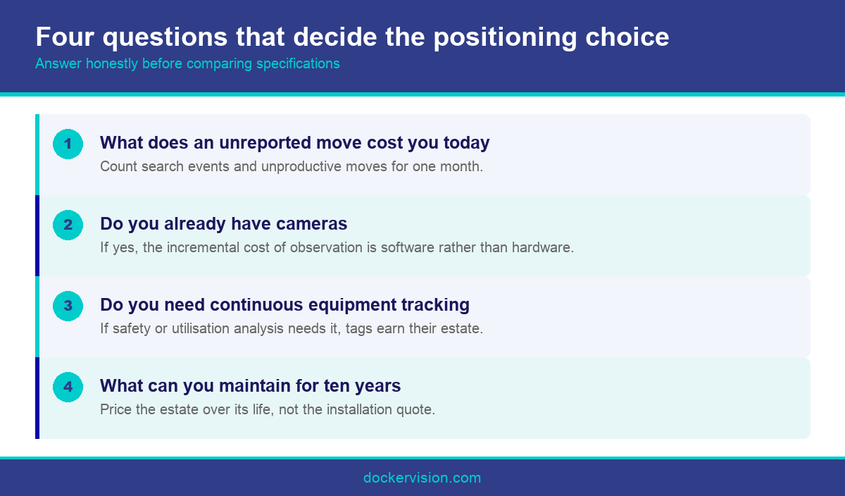
To choose between the three, answer four questions. What does an unreported move cost you today. Do you already have cameras. Do you need continuous equipment tracking for its own sake. And what can you realistically maintain for ten years.
Most mid sized terminals answering those honestly land on equipment positioning plus camera observation, with tags reserved for specific high value equipment. That combination covers the common failure modes without committing to an estate the operation cannot sustain.
Whichever combination you choose, keep a periodic physical check in the process. It is how you validate the technology rather than trust it, and any supplier who suggests you can retire counting altogether is making a claim that no terminal has yet been able to hold to in practice.
Conclusion
Positioning technology should be chosen on failure behaviour and total cost rather than on accuracy specifications. Tags track continuously and demand an estate. Equipment positioning is cheap and inherits reporting gaps. Vision observes rather than infers and rides on cameras many terminals already own. For most mid sized operators the sensible answer is a combination. Ask Docker Vision what your existing camera coverage could already tell you.
Frequently Asked Questions
What is the difference between RTLS and RFID for containers?
A real time locating system tracks position continuously using active tags and fixed readers. Passive radio frequency identification confirms identity when a tag passes a reader, so it is strong at a gate and weak for continuous position in open space.
Is satellite positioning on cranes accurate enough for slot level tracking?
In open yards with clear sky view, usually yes. Accuracy degrades between deep stacks and under structures, which unfortunately are the areas where a misplaced container is most expensive and most time consuming to locate.
Why does behaviour on unreported moves matter more than accuracy?
Because unreported moves are the largest cause of yard drift. A very accurate system that stops reporting when a box moves outside its scheme leaves the same gap as manual recording, just with better numbers on the positions it does see.
Can cameras installed for gate OCR really help in the yard?
They can contribute sightings, which are observations of a specific container at a specific place and time. Coverage depends entirely on camera placement, and deep stacks create genuine occlusion, so treat it as one source among several.
Which technology is cheapest to install?
Equipment based satellite positioning is usually cheapest as a standalone project. Camera derived location is cheapest where cameras already exist for gate or crane work, because the incremental spend is software rather than new hardware.
What ongoing costs do tag based systems carry?
Reader maintenance across the yard, tag issuing and replacement, network support and periodic coverage verification. Price the ten year total rather than the installation quote, and ask an existing user what coverage looks like three years in.
Should we choose one technology or combine several?
Most mid sized terminals do better by combining equipment positioning with camera observation and keeping tags for specific high value equipment. Combination covers the common failure modes without committing to a yard wide estate the operation cannot realistically sustain.
Does positioning replace physical stocktakes?
It reduces their frequency rather than eliminating them. A periodic physical check remains the way you validate whatever system you have chosen, and any vendor promising to remove it entirely is making a claim worth probing hard.
How does position data reach the operating platform?
Through the same interface routes that carry gate events, so a divergence becomes a work order rather than a dashboard entry. See our note on edge processing in the terminal for where the computation happens.

Leave A Comment